Local Weather for Dublin, OH: (32°F/0°C) 
Rating: Rated 4+
Platform: Requires iOS 8.0 or later. Compatible with iPhone, iPad, and iPod touch.
Date Published: Mar 02, 2017
App Version: 3.2.3
Language(s): English, Danish, Dutch, Finnish, French, German, I
Author: Impala Studios B.V.
Application Description:
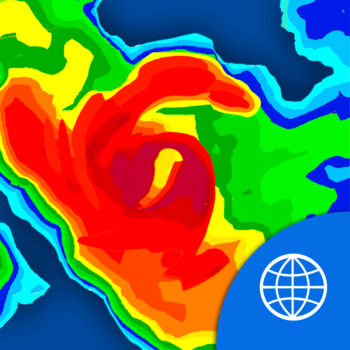
NOAA World Radar is the most complete, reliable, and stunning weather radar app available.
Use World Radar to see NOAA doppler radar of the USA and many other countries or regions worldwide: CANADA, MEXICO, EUROPE: FRANCE, UNITED KINGDOM, GERMANY, SPAIN, PORTUGAL, NETHERLANDS, SWITZERLAND, NORWAY, SWEDEN, FINLAND, DENMARK, APAC: JAPAN, HONG KONG, KOREA, TAIWAN & AUSTRALIA! One look tells you the current weather condition, accurate forecast and how it could impact you.
1 HOUR RADAR FORECAST
This is the first application in the world that calculates accurate rainfall radar forecasts worldwide one hour ahead!
HURRICANES
Stay on top of the hurricane’s development, it’s predicted path (and changes of such), how it can affect you, wind speed, wind quadrants, and much more. And the best part? All of this is visual!
NOAA WEATHER WARNINGS USA
NOAA World Radar displays NOAA's weather warnings graphically on maps. This makes them easy to see.
DETAILED DAILY AND HOURLY WEATHER FORECASTS
A unique Daily and Hourly weather forecasts for all locations worldwide. See accurate weather forecasts for the next hour, and five hours from now, all on the same screen.
UNIQUE CHARTS
NOAA World Radar provides you with accurate charts concerning the development of the most important key weather-related values in any location you wish, and lets you zoom in to see how they could impact you. This gives you a clear view of: Temperature, Precipitation, Wind, Pressure, and UV… and these charts can run anywhere from hourly to 10 days in the future.
UNLIMITED LOCATIONS
Very usable for a detailed weather forecast of a certain location. Just search for the city, and add it to your list. This gives you worldwide Doppler Radar information in the palm of your hand.
UNIQUE INTERFACE
All of the above sounds complicated, but it’s not. NOAA World Radar combines all of that information into a very elegant (and logical) interface. This app is easy to use.
SUMMARY
NOAA World Radar is the fastest, easiest-to-use, and most up-to-date worldwide weather radar application available now. One look shows you the current weather condition, accurate forecast, and how it could impact you. And, of course, it shows you the moving map.
Whether it is your location or some other preferred location worldwide, NOAA World Radar has you covered. Rain, clouds, fog, hurricanes, tropical storms, thunderstorms, tornados, flooding, temperatures… it’s all there in one screen. And detailed current conditions, daily and hourly forecasts, forecast charts and motioned radar images are one tap away. It’s a must-have.
Get App

Get your family and home ready for a tornado. The American Red Cross tornado app is the complete solution you need to unMore...

Graph the weather and see the weather for your calendar events. Use a 7 day scrollable minute-by-minute graph of temp, fMore...
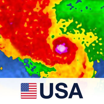
NOAA Radar USA is your specialized animated weather resource for:
- Tracking Rain and Storms live with the radar on yMore...

Be ready for severe weather with Hurricane by American Red Cross. Monitor conditions in your area or throughout the storMore...
iHurricane by HurricaneSoftware.com Is The Most Popular Hurricane Tracking App For iPhone/iPad and iTouch.
- FroMore...

Hurricane tracking on a Google Maps background. Shows the tracks and forecasts of active hurricanes tropical storms. AlMore...

**One of the top 6 hurricane tracking apps - CNN**
**Readers’ Pick: Most innovative and useful hurricane app – FaMore...
A free weather application with no advertising, no tracking using the National Weather Service API.
Features, cuMore...